Hardware and software requirements :
CPU : 350 MHz
Memory RAM : 128 Mbytes
Space on disk : 15 Mbytes
Video : Color monitor and 24 bits card
Windows version : 98SE/2000/Me/XP/2003
Linux version : Ubuntu "Feisty Fawn", Debian "etch", Redhat 9.0, Gentoo 2006.0
For other distribuitions : kernel 2.4, libc 2.2, gtk+ 2.4
For the help : .chm visualizator
Installation instructions :
Windows :
1) Double click on the installer file
The installation will create an icon on Start >> Programs >> Suri menu.
The installation will create an icon on the Desktop
2) To execute :
Go to Start >> Programs >> Suri >> Suri-Pluma
Or double click on the Suri Pluma icon placed on the Desktop
3) To uninstall :
Don't erase the files manually
Go to Start >> Programs >> Suri >> Suri-Pluma Uninstall
GNU/Linux :
1) Execute the downloaded .package file; double click or open a console and type :
# bash SuriPluma-v1.1.package
Follow the instructions
2) To execute :
Go to the Applications Menu >> Graphics >> Suri Pluma
Alternatively :
Go to the Applications Menu >> Lost and Found >> Suri Pluma
3) To uninstall :
Go to the Applications Menu >> System >> Manage 3rd Party Software
Select Suri Pluma
Uninstall
Introduction to Suri Pluma :
Suri Pluma is designed for the navigation and basic processing of satellite images.
Reads and exports the most popular satellite image formats automatically with georreferenced information support. It has tools of visualization and analysis such as enhancements, zoom, measurement of areas and distances, information of geographic position and detailed ancillary information of the images.
Designed using state-of-the-art programming techniques, it provides simple and intuitive methods to extract qualitative and quantitative information of the different remote sensing data sources.
It takes advantage of the hardware resources available, working fast with minimum requirements.
Conceived to offer a simple, fast and powerful solution, this tool allows using satellite images and the Remote Sensing technologies in a simple way.
Suri Pluma features :
General features
Multiplatform, Linux and Windows
Low hardware and software requirements
Available in English and Spanish
User Interface
Windows based single-document user interface (SDI)
Intuitive graphic user interface, making the tasks simple for both beginner and advanced users
Complete Help available
Input file formats
Automatic opening of Fast Format images (SAC-C, Landsat), CEOS SAR (ERS, Radarsat, others), NOAA KLM L1B, ENVI HDR, Tiff/GeoTiff
 Supports standard graphical formats such as jpeg, png, xpm and bmp
Supports RAW file format, with user defined parameters
Automatic detection of the data format, no need to import data
Direct access to image data, no need for data type conversion
Supports all image sizes, without limitations
Opens multiple images simultaneously, without running out of memory
Automatic ingestion of georreference data and other ancillary data
Visualization tools
Both RGB combination and grayscale available
Band combination from multiple files available
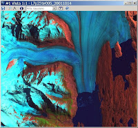
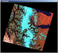
Navigation using multiple windows: Detail (to see full resolution and zoom) and Panorama
Linear, nonlinear and histogram equalization enhancements available.
Zoom in and zoom out capabilities available
 Can save the screen with the actual enhancement to a standard digital graphical format file
Analysis tools
Area and distances measurement tools available
Planar coordinate and pixel value displaying in real-time
Geolocation tool available: look for the area of interest based on geographical or planar coordinates
Anciliary data information tool available
Exporting tools
Exports to TIFF/GeoTIFF and ENVI
Can combine bands from different files
Can select a spatial subset for the output image
Keeps the georreference information of the input data
http://www.suremptec.com
contact@suremptec.com.ar


